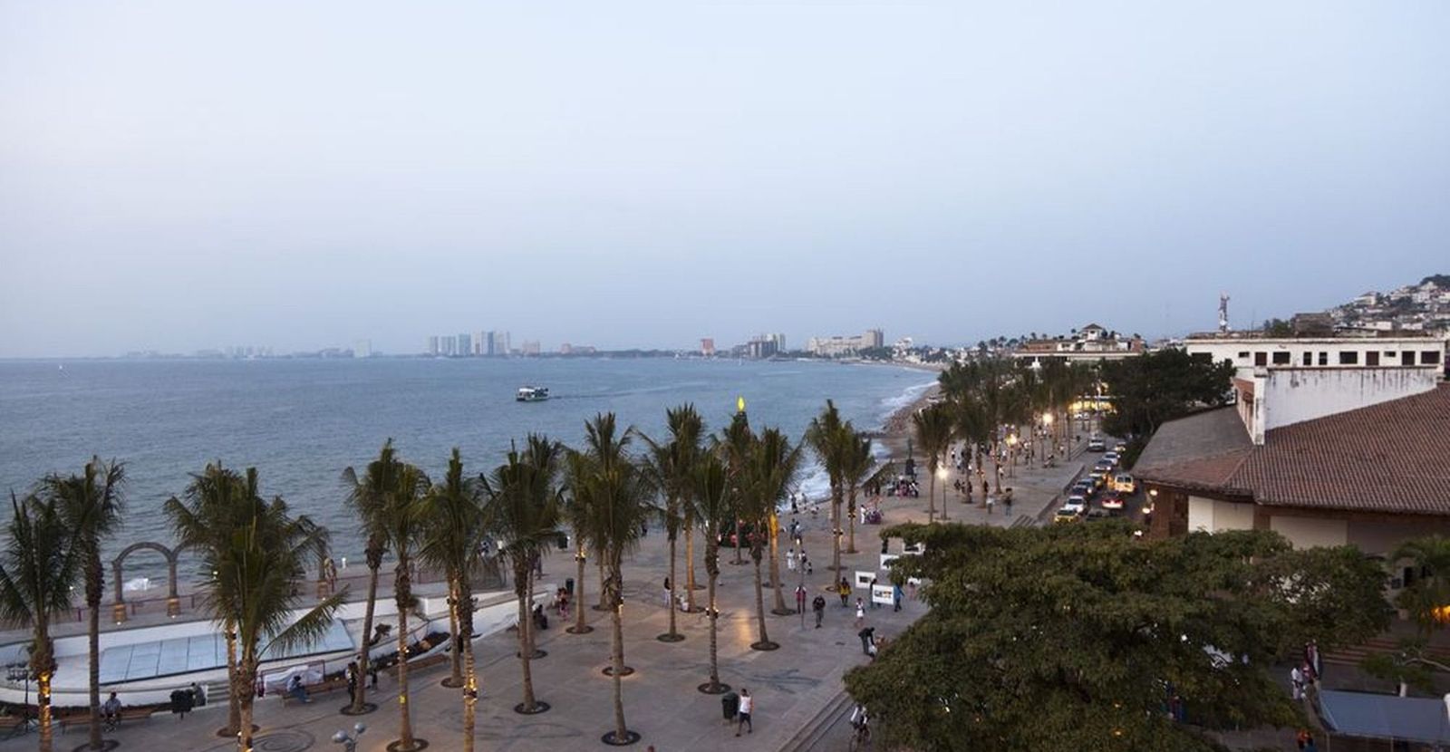
What to do in Puerto Vallarta and how to plan your trip
A Mexican town that never stopped being one, wrapped around the biggest bay on the Pacific coast, with jungle behind it and villages down the shore you can only reach by boat.
- 10transportation zones
- 72hotels
- 100 kmof bay
- 360days of sun a year
- UTC−6Central time

Everything you need to know about Puerto Vallarta
Puerto Vallarta grew up as a fishing and mining port and only became famous when a film crew arrived in 1963, which is why it still has cobbled streets, a parish church with an iron crown and neighbourhoods where people live. It sits on the eastern shore of Banderas Bay — one of the largest bays in the world — a hundred kilometres of coastline held between two headlands, with the Sierra Madre coming down almost to the water behind the town. The tourist board makes two claims for it that matter to a visitor: an average of 360 sunny days a year, and a place among the ten safest cities in Mexico. South of the centre the road runs out, and the villages beyond it — Yelapa, Quimixto, Las Animas — are reached by panga from the pier.

Getting to Puerto Vallarta
- Puerto Vallarta Airport (PVR)Six kilometres north of the centre, beside the marina, with direct flights from across the US, Canada and Mexico.
- Highway 200The coast road runs north into Nayarit — Nuevo Vallarta, Bucerias, Sayulita and Punta Mita — and south towards Mismaloya and El Tuito.
- Cruise terminalShips dock at the Maritime Terminal north of town, which is why the Malecon fills between ten and five on port days.
Beyond the beach
Three sides of the same bay, and they are not alike.


Good to know
- LanguageSpanish, with English throughout the tourist areas and a large North American resident community.
- CurrencyMexican peso (MXN). US dollars circulate in the resorts, always at a worse rate than a card.
- Time zoneUTC−6, Central time, all year: Mexico dropped daylight saving in 2022. Nayarit, across the bridge, is on the same clock.
- Power127 V, 60 Hz, the same flat plugs as in Canada.
- WaterBottled water. Puerto Vallarta’s tap supply is certified but locals still drink bottled.
- Emergencies911 nationwide. The city has several private hospitals used to treating visitors.
Transfers from the airport to every zone of Puerto Vallarta are a fixed price per vehicle, with the driver waiting at the exit. See availability.
What to see and do in Puerto Vallarta
The full list, not a top three: what the tourist board of the destination puts first.
A kilometre of seafront sculpture walk ending at the Los Muertos pier, and where the town goes at sunset.
Behind Los Muertos: cobbled streets, small hotels, the restaurant district and the heart of the city’s LGBT scene.
The parish church with the iron crown on its tower, and the most photographed thing in the city after the Malecon.
The town beach, busiest and easiest to reach, with the pier that doubles as the water-taxi stop.
The villages at the bottom of the bay with no road to them. Water taxis leave from Los Muertos pier and from Boca de Tomatlan several times a day.
Humpbacks come into Banderas Bay to calve from December to March. The board leads with it, and boats leave from both the Marina and Los Muertos.
Rock islands twenty minutes south with caves, cliffs and the snorkelling every boat trip stops at.
North of the centre: the marina, the golf course and the cruise terminal, which is why the Malecon fills between ten and five on port days.
Cross the river north and the coast changes: Nuevo Vallarta’s resorts, Bucerias, the surf town of Sayulita and the point at Punta Mita.
A silver-mining town in the Sierra Madre, an hour and a half inland, at 1,500 metres and fifteen degrees cooler.
Behind the town: zip lines, canopy tours, mountain biking and rivers, all within forty minutes of the beach.
What the board pushes after the beaches: a restaurant scene that punches well above the town’s size, plus the market and the taco stands of the old town.
Beaches of Banderas Bay
From the town beaches you can walk to, round to the ones with no road at all.
The town beach, in the Zona Romantica, with the pier, the beach clubs and the most crowded sand in the city.
Just south of town, a series of small coves between rock outcrops. Calm, clear and good for snorkelling.
Twenty minutes by boat from Boca de Tomatlan. A single row of palapa restaurants and a calm, shallow bay.
At the far south of the bay, reachable only by water. A village with a waterfall behind it and no through road.
North, in Nayarit, on the way to Punta Mita. Long, open and far less built up than the town beaches.
When to visit Puerto Vallarta
Four seasons for one destination. Pick yours by weather, crowds and price.
The dry season and the high one: 20 to 30 °C, no rain, humpback whales in the bay and the town at its fullest.
Hot and dry before the rains, with the sea warming. Quieter and noticeably cheaper.
The rainy season: hot, humid, green, with storms in the late afternoon and the lowest rates of the year.
The rain tails off, the hills are still green and the crowds have not arrived. The best-kept secret of the calendar.
Getting around Puerto Vallarta
A bus, a boat and a bridge, and what each one is for.
Cheap, frequent and confusing until you learn the windscreen signs. They cover the whole bay, including Nayarit.
From Los Muertos pier and Boca de Tomatlan to the southern villages. The only way to reach Yelapa, Quimixto and Las Animas.
Both operate in the city. Taxis quote by zone, so agree the fare before you set off.
Airport to hotel anywhere around the bay at a fixed price per vehicle, including across the bridge into Nayarit.
Areas of Puerto Vallarta we serve
10 transportation zones, each with its own page: hotels, times and fixed transfer prices from the airport.


Marina Vallarta
Puerto Vallarta- SUV US$154
- Group van US$167
Puerto Vallarta Hotel Zone
Puerto Vallarta- SUV US$172
- Group van US$209
Downtown & Zona Romantica
Puerto Vallarta- SUV US$172
- Group van US$209
Punta Negra & Mismaloya
Puerto Vallarta- SUV US$173.90
- Group van US$240
Vidanta Nuevo Nayarit
Puerto Vallarta- SUV US$154
- Group van US$167
Nuevo Vallarta Hotel Zone
Puerto Vallarta- SUV US$173.90
- Group van US$240
Nuevo Vallarta
Puerto Vallarta- SUV US$167.40
- Group van US$250
La Cruz de Huanacaxtle
Puerto Vallarta- SUV US$220
- Group van US$300
Punta de Mita
Puerto Vallarta- SUV US$226
- Group van US$245
Playa Mita · Iberostar
Puerto Vallarta- SUV US$265
- Group van US$608
Hotels in Puerto Vallarta we pick up from
Fixed price to every hotel in the zone. If yours is not here, type it in the search box.
Tips from our local team in Puerto Vallarta
What travellers ask us most, answered by the people who live here.
The airport exit is full of timeshare desks
They stand between arrivals and the door offering rides and "welcome gifts". Keep walking to your booked driver.
Old Town and the marina are different vacations
The Zona Romantica is cobbles, small hotels and walking everywhere. Marina Vallarta and Nuevo Vallarta are resorts with a taxi ride into town.
The south shore has no road
Yelapa and Las Animas are boat-only, and the last water taxi back is in the late afternoon. Check the return time before you settle in for lunch.
Whales are a winter thing
Humpbacks are in the bay roughly from December to March. They calve here, and from the Malecon you can sometimes see them without a boat.
Nayarit is across a bridge, not across the road
Nuevo Vallarta, Bucerias and Sayulita are in another state. It changes nothing for the clock but everything for how long the taxi takes.
Rain here means afternoon, not all day
In the wet season mornings are usually clear and the storm arrives late. Plan the beach early and dinner under a roof.
Puerto Vallarta travel guides
Practical, written by the team that drives the area every day.

Marina Vallarta: the shortest transfer, and the weakest beach
Marina Vallarta was built in the eighties around a working marina, and it sits a few minutes from the airport terminal — the shortest transfer anywhere …
2 read
Nuevo Vallarta is not Vallarta, and it is not even the same state
North of the airport, across the Ameca river, Puerto Vallarta ends and Nayarit begins. Nuevo Vallarta is the resort strip on that side: a long, flat, wa…
2 read
Puerto Vallarta: a town that kept its center
Puerto Vallarta is the rare Mexican beach destination where the old town is still the good part. Cobbled streets running up the hill, a church with a cr…
3 readGetting to Puerto Vallarta from the airport
Fixed price per vehicle to every zone, driver at the exit with your name. Full details on the airport page.
Transportation prices per zone in Puerto Vallarta
| Transportation zone | Drive time | Passenger van · up to 66 6 | Luxury SUV5 5 | Extended van11 11 | See availability |
|---|---|---|---|---|---|
| Marina Vallarta | 25 min | US$129.99 | US$154 | US$167 | See availability |
| Puerto Vallarta Hotel Zone | 34 min | US$144 | US$172 | US$209 | See availability |
| Downtown & Zona Romantica | 34 min | US$144 | US$172 | US$209 | See availability |
| Punta Negra & Mismaloya | 63 min | US$159 | US$173.90 | US$240 | See availability |
| Vidanta Nuevo Nayarit | 25 min | US$129.99 | US$154 | US$167 | See availability |
| Nuevo Vallarta Hotel Zone | 63 min | US$159 | US$173.90 | US$240 | See availability |
| Nuevo Vallarta | 34 min | US$154 | US$167.40 | US$250 | See availability |
| La Cruz de Huanacaxtle | 30 min | US$158 | US$220 | US$300 | See availability |
| Punta de Mita | 68 min | US$215 | US$226 | US$245 | See availability |
| Playa Mita · Iberostar | 88 min | US$240 | US$265 | US$608 | See availability |
One way in USD per vehicle, taxes, tolls and luggage included. Round trip is the total for both legs. Drive times are estimates without traffic, calculated from distance and speed limits; those marked ≈ are approximate.